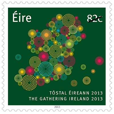
 Ireland 2013-01-24 On January 24, 2013, An Post issued a new stylized map design helping promote “The Gathering Ireland 2013” a year long tourist promotion program for all things relating to Ireland. “The Gathering is a tourism-led initiative that seeks to harness and strengthen the connections between Ireland and its global diaspora. Billed as a spectacular, year-long celebration of all things Irish, The Gathering is an open invitation from the Irish people, to the 70 million people worldwide that claim Irish ancestry and indeed to anyone with a love of Ireland, to take a trip to Ireland during the year, and join in unique events being staged in their honour. All around Ireland, towns, villages, communities and families are organising events, festivals and special gatherings that will showcase the very best of Irish culture, tradition and sport to the Irish diaspora. It is hoped that The Gathering will deliver an additional 325,000 visitors, while also enhancing the reputation of Ireland as a warm and engaging place to visit.” The 82c single denomination features a square format showing the entire island of Ireland. “The colourful 82c stamp was designed by Irish graphic artists Design Factory, and builds on elements of The Gathering’s official logo to form a map of Ireland, representing the huge range and sheer number of events planned around the country this year.” 82c covers worldwide airmail postage for a standard letter up to 50g. [Design Factory appears to be behind some other postal issues, such as Ireland’s 2011 Europa issue. — web admin]
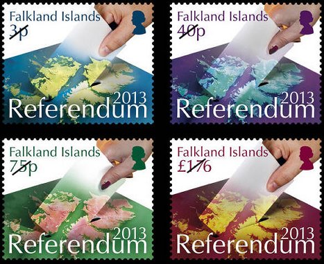 Falkland Islands 2013-02-15 (planned) To mark the upcoming sovereignty referendum on March 10-11, 2013, the Falkland Islands Philatelic Bureau plans to issue a set of four single stamps and a mini-sheet. The for single stamps, are planned in denomina-tions of 3p, 40p, 75p and £1.76. The denomination of the single stamp mini-sheet is £3.00. The stamps and mini-sheet share a common theme showing the islands, with a hand holding a ballot paper, being submitted into a ballot box, with the opening of the box near Falkland Sound, between the two islands. A satellite image of the islands appears to have been used, possibly with alternate band combinations, to match the multi-colored backgrounds of the oceans and text on the stamps. On the mini-sheet, the question of the referendum, “Do you wish the Falkland Islands to retain their current political status as an Overseas Territory of the United Kingdom?” is shown in the lower right hand corner. In the upper left of the mini-sheet is the quote “a people’s right to self determination is a fundamental modern democratic right” appears to be from a statement given by R. Edwards, a member of the Falkland Islands Legislative Assembly, in a statement given to the United Nations Committee of 24 (Special committee on Decolonization) June 14, 2012.
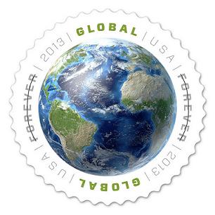 USA Global Forever 20130128 On January 28, 2013, the United States Postal Service (USPS) will introduce a new Global Forever® Rate stamp suitable for international postage. The Global Forever® stamp offers a single price for any First-Class Mail International 1-ounce letter to any country in the world. The Global Forever® stamp is in response to the USPS rate change which takes effect on January 27, 2013. This stamp features a rendering of Earth composed of images created from satellite data and redesigned with 3D computer technology. The view of our planet shows the Atlantic Ocean flanked by the Americas, Africa, and part of northern Europe. In the stamp art, the globe is isolated on a white background. The shape of the stamp is round. The text, which surrounds the image of Earth, includes the words “Global Forever.” The circular stamps are being issued in self-adhesive sheets of 20 at the $1.10 rate, or $22.00 per sheet.
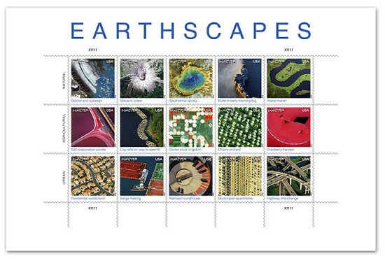 USA 2012-10-01 On October 1st, 2012, the US Postal Service issued a new sheet of Forever stamps featuring fifteen aerial views of landscapes. Two of the stamps are images from the Landsat 7 satellite. The sheet was released October 1 to kick off National Stamp Collecting Month, and portrays a number of landscapes as viewed from heights of several hundred feet above the Earth to several hundred miles in space. The sheet contains imagery in three categories: natural, agricultural, and urban. The two stamps that feature Landsat images Volcanic Crater and Center-pivot irrigation — depict a natural disaster site, Mount Saint Helens, and an agricultural practice that is common in the Garden City, Kansas area. As part of the Landsat 40th Anniversary Celebration this summer, the USGS and NASA held an online contest in which more 14,000 people voted on their Top Five favorite Earth as Art images.
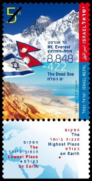 Israel 2012-09 In September 2012, Israel Post released a joint issue with Nepal Post marking full diplomatic relations established between the two countries in 1960. The issue depicts the two elevation extremes on the Earth. The highest, Mount Everest, in Nepal at 8,848 meters above sea level, and the lowest, Dead Sea, in Israel at -422 meters below sea level. CartoPhilatelists will be interested in the map shown on the tabs of the Israel sheet. The stamps themselves and the Nepal issue do not feature maps or tabs, respectively.
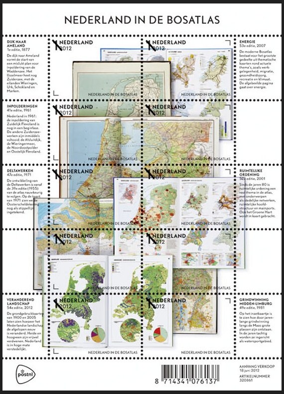 Netherlands 2012-06-18 On June 18, 2012, the Netherlands Post (PostNL) issued a fascinating sheet depicting the well known “Bosatlas” an educational atlas used by schools throughout the Netherlands. The sheet was issued to celebrate the latest edition of the DeGrote Bosatlas, the most popular atlas used in Dutch classrooms. “The Bosatlas, which forms the foundation of geography teaching in the Netherlands, has shaped how many generations of Dutch people view the world. The first Bosatlas was created in 1877 by Groningen teacher P.R. Bos and entitled Bos’ Schoolatlas der geheele aarde (Bos’s School Atlas of the Whole Earth). Many editions of the atlas have since been issued, with each new one summarising changes in the world, society and education.” The images of the Netherlands shown on the Bosatlas stamp sheet feature ten different stamps with the non-value indicator “1” and the designation “Nederland 2012.” The sheet depicts the inside pages of seven editions of the Bosatlas, the first one published in 1877, along with maps published in 1961, 1971, 1981, 2001 and 2007, and the very latest edition from 2012. The images on the sheets are arranged in the shape of the Netherlands. The sheet margins contain text explaining the contents of the pages shown. The font used is “Nobel,” a san serif typeface designed in the 1930s and used in all editions of the Bosatlas since 2004. In addition to the stamp sheet featuring ten different stamps, two stamp booklets, a prestige booklet and two first day covers will also be available. [Many thanks to Society Vice President Mark Honig who alerted us to this stamp prior to issue. There are a number of fascinating links about the backstory of the young designers who created this issue. If you have specific questions, please contact Mark. — web admin]
|
Welcome to the CartoPhilatelic Society Celebrating our 71st Year as a Society. Come and Join Us!
The CartoPhilatelic Society has entered our 71st year as a Society! In 1955 a group of philatelists with a keen interest in map stamps founded the CartoPhilatelic Society. Today we carry on their passion for map stamps in the collections we assemble and the research we conduct.
Come and join us as we look forward to the future!
Web Site Last Updated:
April 25, 2026

A one year term of membership for the CartoPhilatelic Society runs April 1 through
March 31. Unless you have pre-paid for multiple years, or already renewed you dues, your membership has expired at the end of March 2026
If you have not yet renewed, please continue to support the Society and renew your dues for the April 2026 through March 2027 term as soon as possible.

A big "Thank You!" to all those members who have recently renewed their membership! The CPS appreciates your continued support and donations.
Visit our Membership page for information.
|
|
 CPS Resource Centre